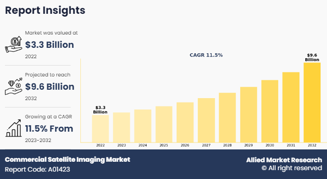
Commercial Satellite Imaging Market to Register a Growth at 11.5% CAGR to Top USD 9.6 Billion by 2032

Commercial Satellite Imaging Market Size, Competitive Landscape
Surged usage of satellite data in smart cities and connected vehicles along with rise in application in defense and government services fuel the market growth.
WILMINGTON, DE, UNITED STATES, July 24, 2025 /EINPresswire.com/ -- Commercial satellite imaging market size generated $2.63 billion in 2020, and is estimated to reach $6.99 billion by 2030, witnessing a CAGR of 10.8% from 2021 to 2030.
Rise in usage of satellite data in smart cities development and connected vehicles, surge in dependence on location-based services, and increase in applications in government and defense services drive the growth of the global commercial satellite imaging market. However, stringent government regulations regarding usage of satellites and limited availability of aerial imaging restrain the market growth. On the other hand, rise in incorporation of new technologies is projected to open new opportunities in the next few years.
Download Report (252 Pages PDF with Insights, Charts, Tables, Figures) at https://www.alliedmarketresearch.com/request-sample/1751
Increase in applications of satellite imaging services such as geospatial mapping, disaster mapping, urban planning, and energy management is expected to drive the growth of the commercial satellite imaging market. The major players in the market have developed and launched new satellites and image processing software to cater to a wider customer base across various nations globally.
Increase in applications of satellite imaging services such as geospatial mapping, disaster mapping, urban planning, and energy management drives the overall growth of the market. The commercial satellite imaging market growth has been fueled by the increasing demand for high-resolution imagery and data-driven decision-making across various industries. Moreover, rise in requirement of satellite imaging data analytics from various industries that need critical information regarding geospatial and environmental conditions for effective resource management fuels the market growth. Satellite imagery is used in various commercial applications such as selection of construction sites, surrounding areas, route planning, monitoring of infrastructural projects, and 3D modeling of excavation areas, which further accelerates the market growth. The commercial satellite imaging market plays a crucial role in providing valuable geospatial data and insights for applications ranging from urban planning to natural resource management.
Buy This Research Report: https://www.alliedmarketresearch.com/commercial-satellite-imaging-market/purchase-options
The commercial satellite imaging market is segmented into application, end user, and region. By application, the market is categorized into geospatial data acquisition & mapping, urban planning & development, disaster management, energy & natural resource management, surveillance & security, defense & intelligence, and others. By end user, it is segregated into government, military & defense, forestry & agriculture, energy, civil engineering & archaeology, transportation & logistics, and others. By region, the market is analyzed across North America, Europe, Asia-Pacific, Latin America, and Middle East and Africa.
Based on region, North America held the highest market share in terms of revenue in 2020, accounting for around two-fifths of the global commercial satellite imaging market, and is expected to maintain its lead position by 2030. This is due to high adoption of satellite imagery among government and military agencies in the region. However, Asia-Pacific is estimated to portray the fastest CAGR of 12.4% during the forecast period, owing to rise adoption of commercial satellite imaging in various end use sectors in the region.
Interested to Procure the Data? Inquire here at https://www.alliedmarketresearch.com/purchase-enquiry/1751
Leading Market Players
BlackSky
Galileo Group, Inc.
European Space Imaging
L3Harris Technologies, Inc.
ImageSat
Planet Labs Inc.
Maxar Technologies Inc.
Airbus S.A.S.
SpaceKnow Inc.
Telespazio France
They are gaining immense popularity and are massively adopted in the government sector, defense & intelligence, transportation, telecommunication, manufacturing, e-retailing, energy, and natural resource management industries. This is attributed to high-resolution imagery to produce updated, highly accurate, and real-time maps by LBSs. Therefore, growth in adoption of LBSs is expected to drive the growth of the commercial satellite imaging industry. The global commercial satellite imaging market size has been steadily increasing due to the growing demand for geospatial data across various sectors.
David Correa
Allied Market Research
+ 1 800-792-5285
email us here
Visit us on social media:
LinkedIn
Facebook
YouTube
X
What Sets Us Apart ? - Allied Market Research
Distribution channels: Energy Industry, Military Industry
Legal Disclaimer:
EIN Presswire provides this news content "as is" without warranty of any kind. We do not accept any responsibility or liability for the accuracy, content, images, videos, licenses, completeness, legality, or reliability of the information contained in this article. If you have any complaints or copyright issues related to this article, kindly contact the author above.
Submit your press release